

Send us a no-obligation enquiry now:+49 (0) 511 81 40 60mail@LSA3D.com

3D Laser Scanning for Urban Planning

Presenting urban design competitions

Alternative designs can be integrated into the true-to-life built environment and visualised, so that even laypeople gain a concrete idea of the planned construction project. The advantages and disadvantages of each design idea can thus be weighed up and analysed.

Urban land-use planning in municipalities

As geometric data is available in addition to the visualisation, dimensionally accurate evaluations and analyses of the existing building stock can be carried out. For example, building heights, setback areas, roof pitches and the size of any surface can be determined quickly and conveniently.

3D building models

Google Earth is a very effective public relations platform, as individual models of buildings can be inserted here and viewed in three dimensions. Further information and links to other websites can be integrated so that users are directed specifically to an offer.

3D city models

Many municipalities have already recognised the advantages of three-dimensional representations of entire districts. Many international cities can already be visited this way, and more and more are being added in Germany too.

Send us a no-obligation enquiry now:

Urban planning 3D scan case study

For the facade competition for the Maritim Hotel in Hannover, we scanned the entire surroundings together with all the hotel’s facades in 3D and made various evaluations available to the design teams. As a result, the “genius loci” of the surroundings could also be accessed remotely and informed the design process.

1

2D facade drawings
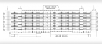
From the scan data, we produced precise, vectorised elevation drawings with Autocad Architecture.

2

ReCap data for Autocad + Revit
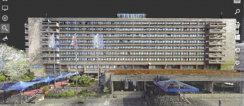
This data model covered the exterior massing of the hotel and its immediate surroundings, extending to the Laveshaus and the New Town Hall.

3

Video animation on Youtube
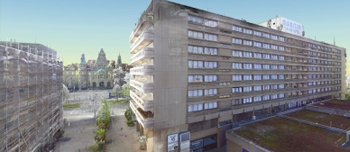
The viewer flies over the building along an animated path and experiences the entire site on film.

Watch the related video on our YouTube channel

Fluganimation Hotel Maritim Hannover

The video is only loaded from YouTube once you click on it. In doing so, data (e.g. your IP address) is transmitted to YouTube (Google). Further details can be found in our privacy policy.

Viewing 3D scans in the browser:

The panoramas open when you click on the site plan. Here we passed the scan data on to all architecture firms in the facade competition using the Point-Cab software. This means no software even needs to be installed. Everything is displayed automatically offline in the web browser.

Animation of the neighbouring buildings:

The Laveshaus is the seat of the Lower Saxony Chamber of Architects and a listed building. The image shows the point cloud from the scan data – it is not a photo!

Here we see the measured image of the facade with the lines from Autocad

This gives you a distortion-free, true-to-scale elevation for building documentation.

The result: the finished drawing of the main facades of the Laveshaus as an Autocad screenshot.

powered by Reuther-Media